The Printed Maps of Devon
Cartobibliography of printed maps of the county of Devon from 1575 to 1837
A short list. All the maps listed below can be seen at my website of the same name.
The maps are numbered in
chronological sequence of first publication. The date given is that which is
known or surmised. The chosen order of preference throughout the catalogue is
surveyor, draughtsman, engraver, author, publisher. Names joined by a slash
indicate that both/all were connected with the original issue. A slash is also
used to identify separate works by the same draughtsman/engraver. Where maps
are commonly associated with another mapmaker or printer the alternative name
is added in brackets. Works not in italics were issued without title page. 80A
and 95A were found after the first edition was published. 80B was originally
109 but has been found in an earlier state. 114 was found to have been
published originally in 1839 and has been transferred to The Victorian maps of Devon.
1. 1575 C Saxton An
Atlas of England
& Wales
2. 1590 W Bowes A
Pack of Playing Cards
3. 1605 W Bowes A
Pack of Playing Cards
4. 1605 v d Keere /
(Speed) The
Counties of England and Wales
5. 1607 Kip /
(Saxton) Britannia
6. 1610 J Speed The Theatre of the Empire of Great Britaine
7. 1612 M Drayton Poly-olbion
8. 1626 J Bill The abridgement of Camden’s Britania
9. 1635 M Simons A Direction for the English Traviller
10. 1643 T Jenner A Direction for the English Traviller
11. 1644 J Jansson Des Nieuwen Atlantis Aenhang
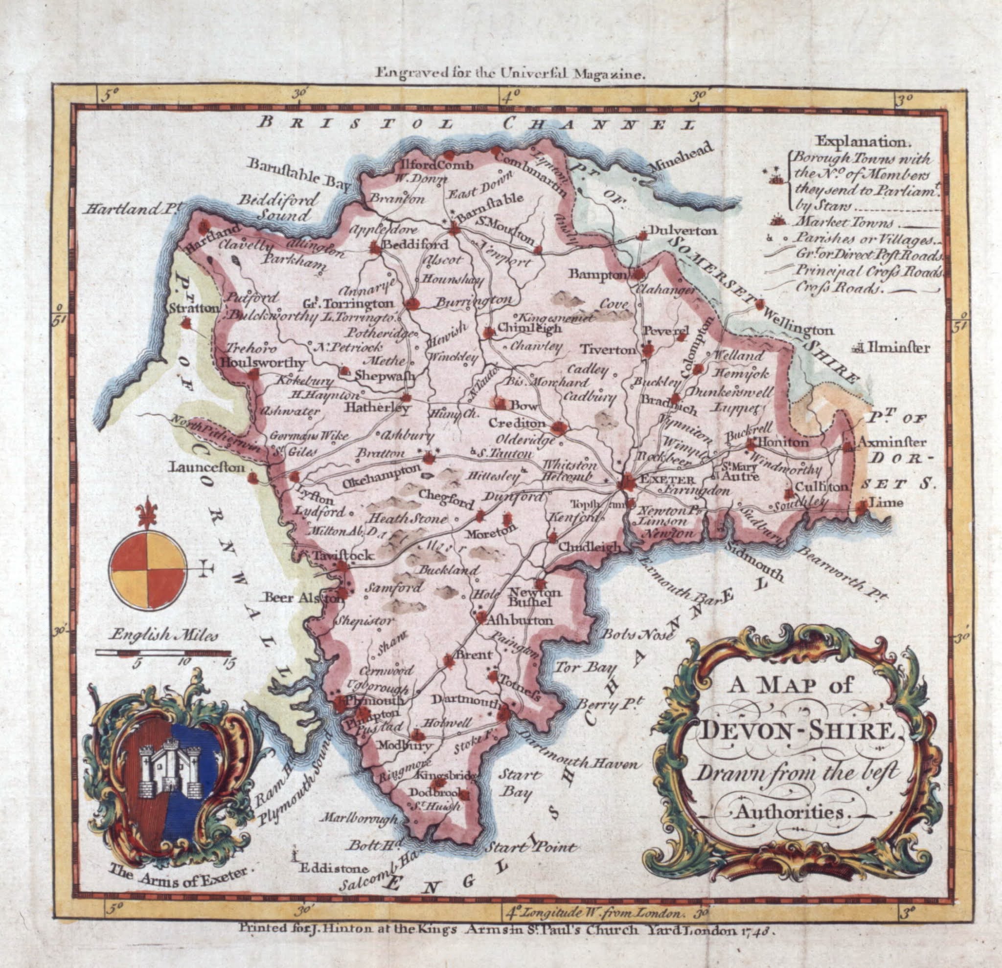
12. 1645 J Blaeu Theatrum Orbis Terrarum
13. 1648 P van den
Keere Atlas minor
14. 1673 R Blome Britannia
15. 1676 R Morden The 52
Counties of England
& Wales
- Playing Cards
16. 1676 W Redmayne Recreative pastimes - Playing Cards
17. 1681 R Blome Speed’s Maps Epitomiz’d
18. 1685 Overton /
(Jansson) Overton
Atlas III
19. 1689 Lamb / Lea /
(Saxton) All the Shires of England & Wales
20. 1694 J Seller Anglia Contracta
21. 1695 R Morden Camden’s Britannia
22. 1701 R Morden The New Description and State of England
23. 1717 J Lenthall A Pack
of Playing Cards
24. 1720 Bowen / Owen Britannia Depicta
25. 1724 H Moll A New Description of England and Wales
26. 1732 R W Seale Nine New & Accurate Maps
26A. 1740 John Pine The Tapestry Hangings of the House of Lords
27. 1741 Badeslade /
Toms Chorographia Britanniae
28. 1743 Read /
(Rocque) The English traveller
29. 1744 Simpson /
Walker The Agreeable Historian
30. 1744 Cowley /
Dodsley The Geography Of England
31. 1748 Hutchinson /
Osborne Geographia Magnae Britanniae
32. 1748 J Hinton The Universal Magazine
33. 1749 Kitchin /
Jefferys The Small English Atlas
34. 1750 T Kitchin The London
Magazine
35. 1750 Exshaw /
(Kitchin) The London
Magazine And Monthly Chronologer
36. 1750 G Bickham The British Monarchy
37. 1754 E Bowen The Large English Atlas
38. 1755 Bowen / Martin The General Magazine of Arts and Sciences
39. 1757 P Meijer Algemeene Oefenschoole
40. 1759 J Gibson New and Accurate Maps of the Counties
41. 1761 R Bennett The New
English Atlas
42. 1763 E Bowen The Royal English Atlas
43. 1764 T Kitchin England Illustrated
44. 1765 B Donn A Map of the County of Devon
45. 1765 Donn /
Jefferys A Map of the County of Devon
46. 1765 J Ellis The New English Atlas
47. 1767 J Gibson The Universal Museum
48. 1767 E Bowen Atlas Anglicanus
49. 1769 T Kitchin Kitchin’s Pocket Atlass
50. 1784 Hatchett /
Walpoole / Hogg The New British Traveller
51. 1787 J Cary New and Correct English Atlas I
52. 1788 J Lodge The Political Magazine
53. 1789 Haywood /
Harrison The History of England
54. 1789 Noble / Cary Britannia
55. 1789 J Cary Cary’s Traveller’s Companion I
56. 1790 J Aikin England Delineated
57. 1791 B Baker The Universal Magazine
58. 1791 W Tunnicliff A Topographical Survey
59. 1794 Neele / Fraser General View of the County
60. 1796 Mutlow /
Marshall The Rural Economy of the West of England
61. 1798 Rowe /
Fairburn The Game of English Geography
62. 1799 Baker / Faden The County of Devon
63. 1801 Smith / Jones
/ Smith Smith’s New English
Atlas
64. 1803 J Wilkes Encyclopaedia Londinensis
65. 1803 R Butters An Atlas of England
66. 1803 J Luffman A New
Pocket Atlas and Geography
67. 1805 Cole / Roper The British Atlas
68. 1805 C Cooke Topographical Survey of Devonshire
69. 1806 J Cary Cary’s Traveller’s Companion II
70. 1806 Neele / Vancouver General View of the Agriculture of ... Devon
71. 1807 J Cary Cary’s New English Atlas
72. 1808 Cooper /
Capper A Topographical
Dictionary of the U. K.
73. 1809 J Cary New and Correct English Atlas II
74. 1809 Mudge / OS The Second Part of the General Survey
75. 1811 Rowe / Allen A Geographical Game - Allen’s English Atlas
76. 1811 W Ebden Laurie & Whittle’s New Map of Devonshire
77. 1812 J Wallis Wallis’s New Pocket Edition of the English Counties
78. 1812 J Wallis Wallis’s New British Atlas
79. 1812 Neele / Cundee The New British Traveller
80. 1813 Palmer / Cary A Topographical Map of Devonshire
80A. 1814 A Arrowsmith Dioc’ Exon’
80 B. 1816 W
Faden / J Wyld Map of the County of Devon
81. 1816 R Rowe The English Atlas
82. 1816 Dix / Darton A Complete
Atlas of the English Counties
83. 1816 E A Ezekiel The Exeter
Pocket Journal
84. 1817 Langley /
Belch Langley’s New County Atlas
85. 1819 Crabb /
(Ramble) A Set
of Cards
86. 1819 Neele /
Pinnock The History and Topography of Devonshire
87. 1820 Hall / Leigh Leigh’s New Pocket Atlas
88. 1820 Wallis / Reid The Panorama: or Traveller’s Instructive
Guide
89. 1822 Mutlow /
Lysons Magna Britannia
90. 1822 J Walker Crosby’s Complete Pocket Gazetteer
91. 1822 Gardner /
Smith Smith’s New English Atlas
92. 1822 G & J Cary Cary’s Traveller’s Companion III
93. 1822 Smith / Davies The Exeter
Pocket Journal
94. 1823 A M Perrot L’Angleterre
95. 1825 Ebden / Duncan Ebden’s New Map of the County of Devon
95A 1825 W v. Schlieben Britisches
Reich
96. 1827 C & J
Greenwood Map of the County of Devon
97. 1829 C & J
Greenwood Greenwood and Compy’s Atlas
98. 1829 J Pigot Pigot & Co’s British Atlas
99. 1830 H Teesdale A New
Travelling Atlas
100. 1830 T L Murray An Atlas of the English Counties
101. 1830 S Hall A Topographical
Dictionary of Great Britain
102. 1831 Walker / Fisher Devonshire Illustrated
103. 1831 Creighton /
Lewis A Topographical Dictionary of England
104. 1832 Dawson / Netherclist Parliamentary
Representation
105. 1832 Dawson / Gardner Report from Commissioners
106. 1832 W Cobbett A Geographical Dictionary
107. 1833 Scott /
Fullarton A New
and Comprehensive Gazetteer
108. 1833 Archer / Pinnock The Guide to Knowledge
110. 1833 House of Commons Accounts and Papers
111. 1834 Dower / Moule Moule’s English Counties
112. 1834 M M Rodwell The Geography of the British
Isles
113. 1835 Creighton /
Lewis A Topographical Dictionary of England
114. 1835* J Pigot Pigot & Co’s Pocket Atlas
115. 1836 W Schmollinger The History
of Devonshire
116. 1836 J & C Walker This British Atlas
117. 1836 S Arrowsmith Third Report from HM Commissioners
+Note: This replaces number
109.
* Note: Pigot has now been
dated to 1839. See next list: Victorian Maps of Devon
Maps published during the reign of Queen Victoria will be found in book
two; The Victorian Maps of Devon –
Printed Maps 1838-1901; published by Devon Books; 2000 and written by the
same authors.